Citadels Introduction
There are many examples of fortifications built in the Highlands of Scotland during the time of the Jacobite Risings. What are less well known are the chain of even older forts, built during the occupation of Scotland by Oliver Cromwell's forces in the mid-seventeenth century.
By the later sixteenth century, castles were becoming indefensible, their high stone walls were fairly easily penetrated by cannon fire. A new type of defence was invented - the artillery fort. Where castles had soared above the local landscape, artillery forts huddled into it, their thick earth ramparts with an outer skin of stone made them much more resistant to cannon fire. The development of the bastion, which allowed the occupants to sweep along their walls with cannon fire, made assault by infantry a very expensive exercise for the attacker. During the misnamed 'English Civil War' of the seventeenth century, castles, fortified houses and towns could only be made defensible by building extensive earth-works around them - in effect turning them into artillery forts.
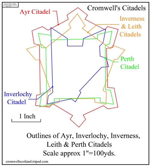
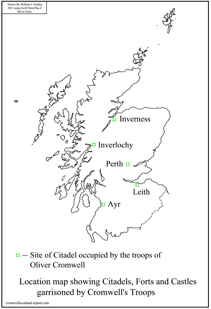
By the end of 1651 Cromwell and his supporters had control of Scotland as well as England , Wales and Ireland. To maintain his hold on Scotland, Cromwell ordered his commander there, General George Monck, to build a string of large forts. The five large citadels, as they were called, were built at Ayr, Inverlochy, Inverness, Leith and Perth, this is the story of these forts.
The citadels were garrisoned by English troops until after the restoration of the monarchy, Charles II then decided that the citadels were unnecessary, or more probably that they were going to be too costly to maintain.
As well as the five large forts, a number of smaller forts and castles were also garrisoned. The story of these is told in the Forts section.
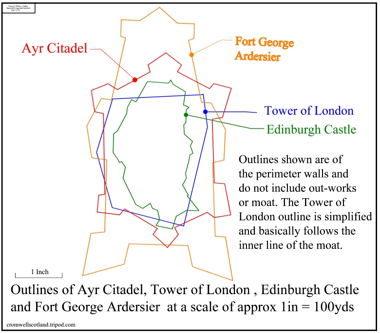
It can be difficult to grasp the massive size of an artillery fort, the fact that Ayr citadel covers an area approximately equivalent to the combined areas of Edinburgh and Stirling castles may give an indication. The outline diagram shows the relative sizes of Ayr Citadel, Edinburgh Castle, the Tower of London and Fort George Ardersier, near Inverness. Fort George, built a century after Ayr, is the finest surviving artillery fort in the United Kingdom and one of the finest in Europe and has remained almost intact in the last two hundred and fifty years.
A glossary of military terms and links to related websites can be found on the General Information Page.
All maps referred to on this site are from the online collection of the National Library of Scotland, except the late nineteenth and early twentieth century maps of Ayr, Inverness and Leith which are modern reproductions of the original 1:2500 Ordnance Survey maps - see General Information Page.
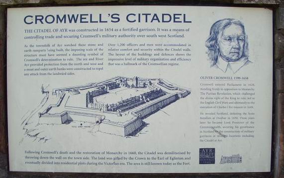
Ayr Citadel
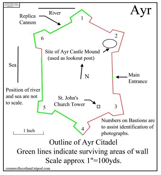
Ayr Citadel was the largest of the five forts, and was built, at the mouth of the River Ayr, using stone apparently from Ardrossan Castle. The citadel was six sided with bastions on all the corners, the bastions flanking the main entrance were larger than those on the seaward facing side. There were also additional out-works on the landward side.
The citadel enclosed Ayr's Parish Church of St. John and when the town protested to Cromwell about the loss of their church they eventually received compensation from him. It is interesting to compare the experiences of Ayr and Perth which seem to have been rather different. Also enclosed was the mound of the former castle of Ayr, built by King William the Lion in the late twelfth century, it is situated near the north eastern bastion (bastion 2 on the diagram). King William also created the Royal Burgh of Ayr in 1205.
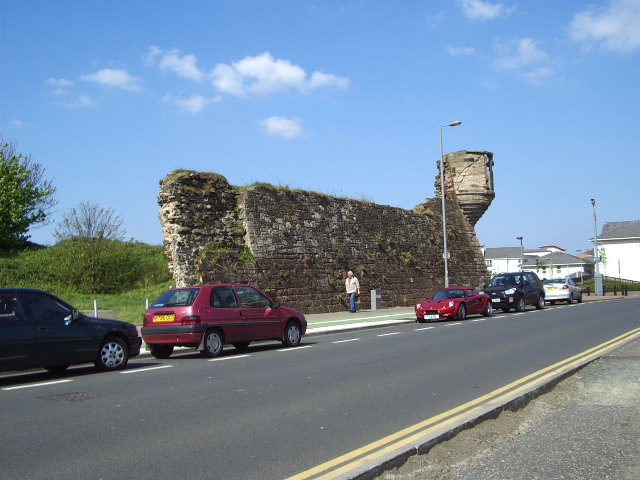
After the restoration the citadel was slighted by demolishing the landward ramparts, bastions (partly) and walls, the only surviving part of this area is the front gateway. of which only the arched top is visible, the rest is buried several feet below the current ground level. Part of the wall of the north eastern bastion (bastion 2) survived into the 20th century and is shown on the 1909 O.S. map. The citadel was gifted to a local nobleman, the Earl of Eglinton, in recognition of his losses. A brewery was built there in the eighteenth century but survived for only a short time.
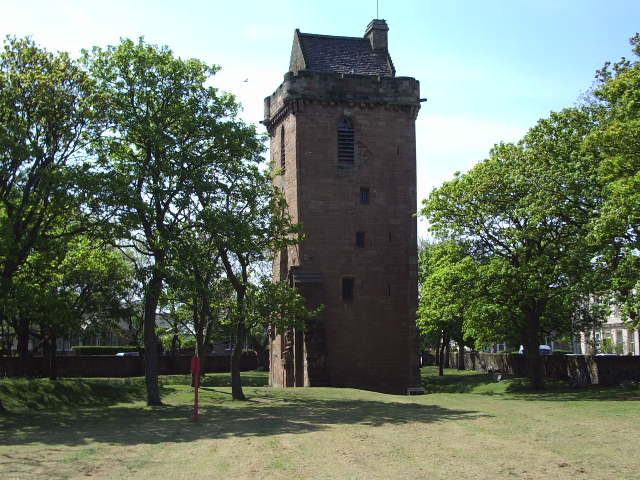
In the nineteenth century the self-styled Baron Miller bought the fort and built extra accomodation on either side of St. John's Tower, the rest of the church having been previously demolished, and called it 'Fort Castle'. He also rebuilt a sentry post on the northenmost bastion (bastion 1), although the original loopholes were considerably enlarged. He called it his garden gazebo, the locals called it 'Miller's Folly'. By the time of his death in 1910 most of the land had been sold for housing. The then Marquis of Bute bought the remaining land and Fort Castle, demolished the additional buildings and restored the tower which he presented to the Burgh of Ayr.
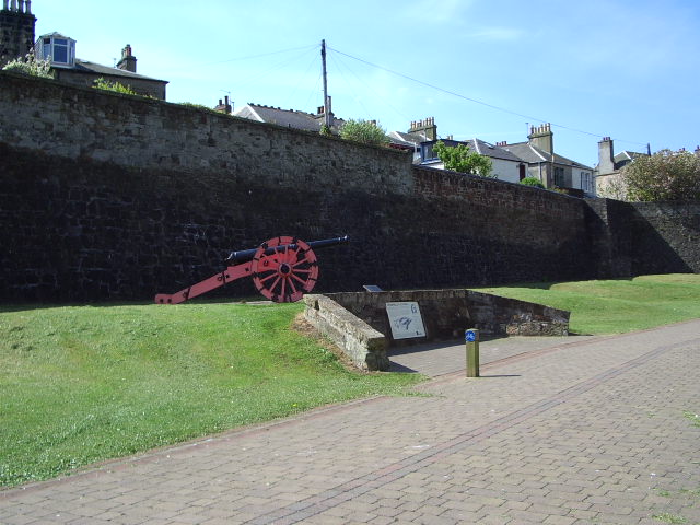
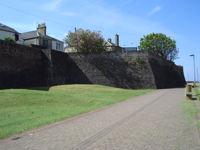
This is the best preserved of the five Citadels and approximately half of the perimeter wall still survives (although not quite to the original height), with the earth ramparts still in place. Houses were built on top of the ramparts, and the fort walls are now acting as retaining walls. A superb view is available on aerial photographs, or on Google Earth & Google Maps.
Ayr maps of the eighteenth and early nineteenth century show the citadel virtually unchanged, only in the later part of the nineteenth century were the outworks on the landward side demolished to make way for a new road, the appropriately named Fort Street. Military barracks, a shipyard and the gas works obscured the seaward side but these were demolished by the late nineteen sixties. Smaller areas of the perimeter wall were demolished to make way for access roads . By 1909 the citadel had taken its modern form, with the inside mostly filled with housing, as shown on the OS map of that date. A sally port is shown between bastions 1 & 6 on the same map, but no trace of this remains.
South Ayrshire Council has erected a sign showing the citadel as originally built, the sign and a replica cannon of the period are outside the north-west rampart (between bastions 1 & 6). Its predecessor council, Kyle and Carrick District Council, placed plaques at St. John's Tower, Miller's Folly and the Main Entrance describing their history. As well as Fort Street, Ayr has a Cromwell Road, Citadel Place and Citadel Lane. The pictures below the fort plan show the citadel sign, the sign and replica cannon, bastion 1 and Miller's Folly, bastion 6, Miller's Folly and St. John's tower.
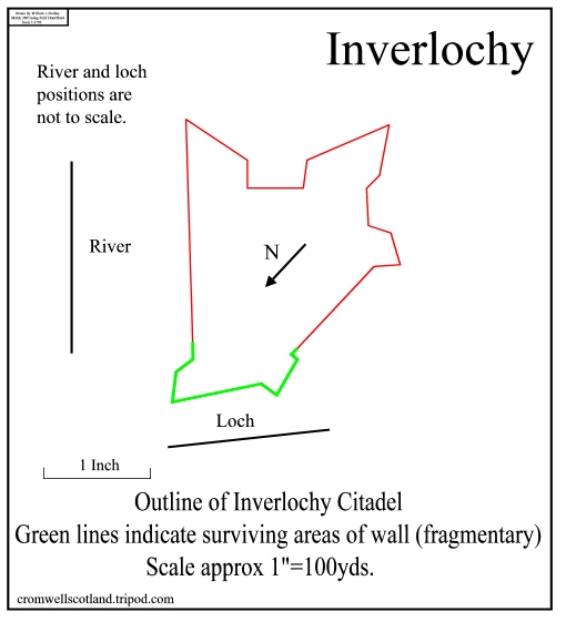
Inverlochy Citadel
Inverlochy Citadel was built at the junction of the River Nevis and Loch Linnhe, the site of the present day town of Fort William. Unlike the other citadels it had no outer stone walls and was an earth rampart only. Inverlochy was slighted in 1660 like the other forts, but unlike them it had a second life. In 1690 it was rebuilt, this time with a stone outer wall, and regarrisoned by troops of King William of Orange on the foundations of the earlier citadel. The fort was rechristened Fort William after the king and the town which sprang up beside it was caIled Maryburgh after his Queen.
I cannot find a map showing Inverlochy Citadel but several maps from the early to mid eighteenth century survive showing Fort William, one from 1736 shows the fort and town. It is interesting to see how improvements are being made to the fort, extra outworks appear and the ravelin alters shape on each successive map. The ravelin and glacis were probably added at the 1690 rebuilt, as none of the citadels had them, only an outer ditch and relatively primitive outworks. Military science had made progress in the intervening years.
The fort survived the Jacobite Rebellions of 1715 and 1745/6. In the latter engagement it was under siege for a considerable time, during which the town of Maryburgh was destroyed, to prevent occupation by the rebels. After the rebellion was suppressed the town was rebuilt but took the name of the fort rather than revert to the original name. Fort William remained manned until the mid ninteenth century when it was abandoned. It was demolished in 1894 to allow the West Highland Railway access to the town. The walls were torn down and today, 117 years later almost no trace is left. A few scattered fragments of the lochside bastion are all that remain of the fort.
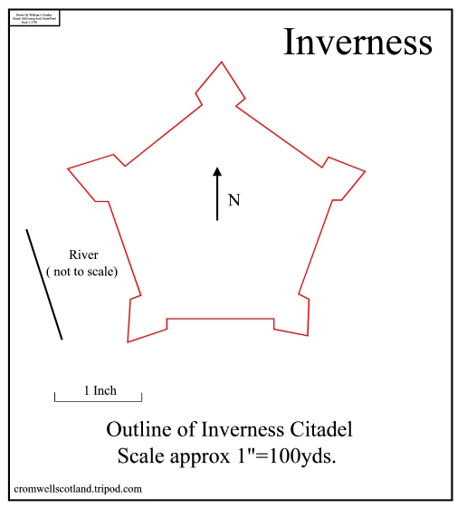
Inverness Citadel
Inverness has had a series of fortifications, castles dating from the eleventh century, the seventeenth century citadel, the early eighteenth century Fort George Inverness built on the castle site and the mid eighteenth century Fort George Ardersier which was built to the east of Inverness near the town of Ardersier. The present day Inverness Castle was built in the nineteenth century.
Inverness Citadel was built using stone from various sources, some came from Aberdeen and some from Avoch castle and Fortrose Cathedral in the Black Isle. Like all of the citadels it was built at enormous cost, in excess of £500,000 which was a lot of money in the 1650's. Also like most of the other citadels it gradually disappeared over the years.
It was still mostly intact in 1716 as is clearly seen on an excellent map showing the town of Inverness, Fort George Inverness (half way up the right side) and on the left hand side, beside the river Ness, Inverness Citadel. It was this map that started me off on my quest to find out more about Cromwell's Citadels, the map is available on the NLS website (Military maps, Fort George Inverness, Inverness in North Britain) - see General Information Page.
By 1821 the outline is becoming blurred , probably due to the stonework being robbed for building. On the 1903 O.S. map the two bastions beside the river and their associated ramparts are gone, the earthworks of the three remaining bastions and their connecting ramparts still remain, but their outline is becoming even more indistinct. Today the remains lie in the middle of an industrial estate with Cromwell Road running through it.
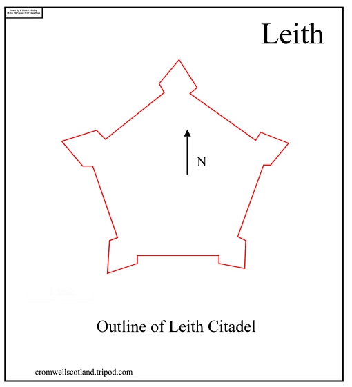
Leith Citadel
Leith Citadel, like Inverness, was built to a pentagonal plan with corner bastions. Again the stone for the walls was mostly taken from other buildings. In this case the nearby Wardie Castle. A map of 1735 shows the citadel still intact, but by 1786 the profile is broken up and no detail can be seen. By 1822 work on the docks seems to have obliterated most traces, there is a triangular area below Commercial Street marked 'Citadel Green' and below it there are possible remains of earthworks. The building marked Leith Fort, on maps from this date, does not refer to the citadel but is a gun battery and associated barracks built from 1780.
By 1837 Cromwell Street runs through the area of the former citadel. Crossing Cromwell Street is Citadel Street which runs into Citadel Green. The 1896 OS map shows the area re-developed, with the former Citadel Green built up. Leith Citadel Station fills the centre of the former Cromwell Street, and is now flanked by East & West Cromwell Streets. Citadel Street still exists, running as before.
Today the area has again been the focus of development, most of the older docks have been filled in and used for office development. East and West Cromwell Streets and Citadel Street are gone, as is the station, but there is a Citadel Place, which may be a remnant of the former Citadel Street. There is no map with a scale to allow determination of the fort's size, but it was possibly of a similar size to Inverness Citadel.
The fort probably straddled Commercial Street and extended from Prince Regent Street in the west to Dock Street in the east. The sole surviving piece of structure is an arched tunnel of one of the entrances, this can be found in Dock Street.
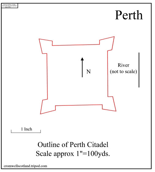
Perth Citadel
Perth Citadel was square with corner bastions, the size is uncertain; scaled from the old military maps on the NLS website, it was 240 yards across the bastions. Another website gives the size as 266 yards, I presume this was measured during the excations (see below), so I have used this size in my illustration.
Perth suffered badly during the construction of the citadel, the town itself was used as a quarry. A hospital, houses, churchyard walls, an old bridge and even gravestones were all used as sources of stone. After the restoration Charles II presented the fort to the town, in compensation for its losses. However when he discovered that the town was making good money from the sale of guns and masonry, he changed his mind and demanded that the town pay him the value of the fort and then refused to listen to the town's complaints.
Maps of 1715 and 1745 show the fort still reasonably intact, except for the area slighted in 1660. By 1783 however only a vague outline is left all the stonework having been extracted. From 1823 onwards all trace of the fort is gone, only the foundations are left under the South Inch, where they were found during excavations in the 1990s.